Satellite Data and Remote Sensing for Agricultural Operations
The agriculture sector was one of the first industries to use satellite data, starting in 1972 when Landsat first began returning regular images of the Earth. These days satellite data is the core of remote sensing technology. Recently, it has received a turbo charge in agriculture due to a few reasons:
- The quality and availability of satellite data has greatly improved with the appearance of the new constellations of satellites on the orbit (like Planet).
- The rise of precision agriculture approach among farmers aimed to improve yields, eliminate disease, maximize profits, and optimize resources.
In this article, we will review the key opportunities of satellite remote sensing for agriculture, its benefits for modern farming, and things to consider for successful implementation.
What Is Remote Sensing for Agriculture?
Remote sensing is the range of technologies used to collect information about objects or areas on a distance, usually from satellites, drones, or aircraft. Satellite imagery is a crucial data source used in remote sensing technology. These are images of the Earth’s surface, captured by sensors on orbiting satellites. The recent report shows that the global remote sensing satellite market will grow from $14.11 bln in 2023 to $29.19 bln by 2030, at a CAGR of 10.9% during the forecasted period. Increasing needs for agricultural monitoring is one of the key drivers of such a drastic growth.
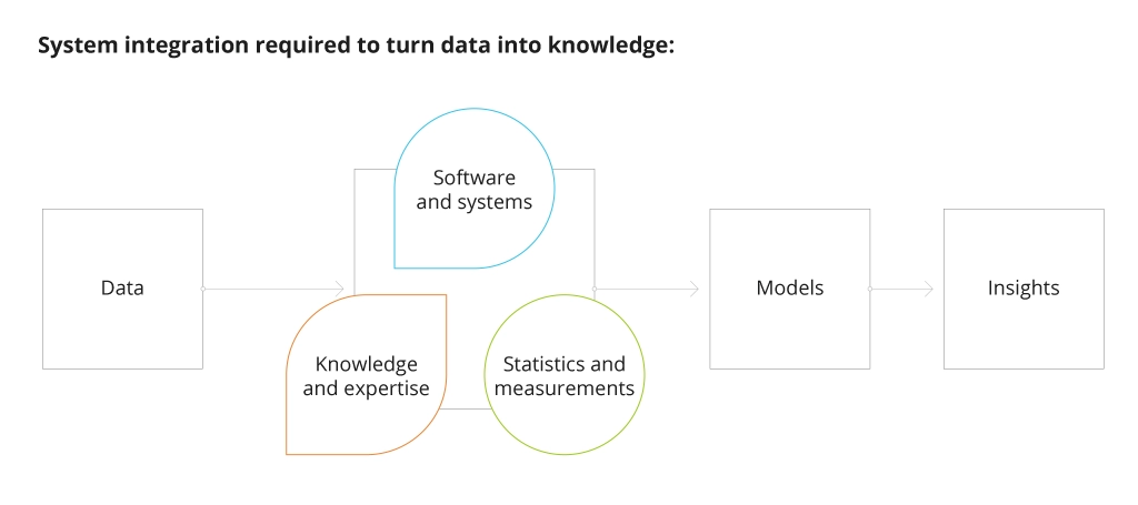
Satellite sensors can provide crop reflectance and structure measurements for detecting various biophysical properties, including vegetation index (NDVI), crop height, development stage, leaf area index (LAI), dry matter content, and others. However, satellite imagery does not provide direct measurements of these properties. Data from satellites needs to be processed with a data science approach to transform earth observation measurements into crop dynamics parameters. The framework for such data transformation includes the following:
In agriculture, satellite data is used by three major categories of stakeholders:
- Agricultural producers
- Agricultural traders, processors and retailers
- Research, statistics, and government authorities.
To get the most value from such data in agriculture, such methods should be used:
- Mapping: A clear picture of the size of land areas used for different agricultural needs.
- Measuring: Transforming satellite data into measurements of agricultural properties like NDVI and crop growth stage (BBCH) using complex algorithms.
- Monitoring: Satellite imagery gives farmers and scientists historical data to understand land use changes, follow crop development dynamics, and spot environmental changes over time.
With proper processing mechanisms, satellite remote sensing technology helps optimize a plenty of processes for agri-specific use cases.
Satellite Remote Sensing Use Cases
Combined with the appropriate data models, satellite imagery helps in the following:
- Crop health monitoring: Satellite imagery time series show changes in crop conditions and help detect potential issues like nutrient deficiencies or crop diseases in early stages to make informed decisions on crop management like schedule updates of fertilization and pesticides application.
- Crop growth stage calculation and yield estimation: Information obtained from satellites can be used to track crop development and, as a result, predict yields. This helps farmers plan harvesting, logistics, storage utilization, and marketing activities.
- Assessing weather patterns: Satellites provide valuable information about upcoming weather changes. Using this information, farmers can optimize their operations and address weather-related risks, including droughts or floods.
- Soil monitoring: Soil characteristics can be identified and monitored with the help of satellite imagery. For instance, the suite of sensors of Sentinel (a few generations of satellites) provides optical and radar data every 5 to 10 days to track changes in soil moisture.
- Water management: Satellite imagery is used for precision irrigation systems that reduces overall water consumption and prevents overirrigation. The latter often leads to soil degradation and nutrient runoff. Also, satellite-based early-warning systems help predict droughts.
- Agricultural operations planning: Satellite data helps detect surface unevenness to define proper field zoning for variable rate seeding and fertilizing to achieve better yields and quality metrics.
Overall, using data from satellites reduces unnecessary field visits, operational costs, and the human resources needed to fulfill different tasks on the farm. It is a powerful assistant for remote farm management.
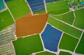
What is Better: Drone vs. Satellite Imagery
Images from satellites and drones are usually considered complementary technologies. However, each has its own use cases, benefits, and challenges. Here are the key differences between drone and satellite imagery that you should consider before using:
- Coverage area: Satellites cover a much larger area than drones. It makes satellite imagery ideal for monitoring large farms and regions. Drones are used for smaller areas or fields.
- Frequency: Satellites capture images regularly while flying around the Earth along their orbit. Depending on the satellite type and speed, an image of a specific area is taken once every 1-14 days, providing farmers with a continuous stream of data about their land and crops. Still, the usability of those images depends on cloud cover. Drone imagery is typically captured less frequently, primarily upon need during the critical crop development phases, and requires physical flights managed manually.
- Resolution: Drones capture images at much higher resolutions than satellites, thus providing more detailed information about crops and soil. Satellites offer broader coverage yet lower spatial resolution, which limits the ability to detect more details.
- Cost: Satellite imagery can be more cost-effective than drone imagery, as the latter implies a higher initial investment for the equipment, maintenance, and skilled operations. Satellite imagery is available for free or ‘as a service’ on a subscription basis for higher-resolution imagery.
- Timing: Satellite data can be received in a certain period, depending on the satellite class. For instance, Sentinel needs two weeks to spin around the Earth. A quality image of a particular location area can be obtained in 2-4 weeks, considering the season, cloud coverage, and other conditions. Planet Labs satellites make a complete circle around the Earth once per day, so the data update period is much faster. These data are available as paid commercial services. However, even from Planet Labs, obtaining images daily is impossible. On the other hand, drones can provide images nearly in real-time and whenever needed.
- Cloud coverage: Optical imagery delivered by satellites like Sentinel 2 is limited by cloud coverage since optical sensors cannot penetrate through clouds. In such conditions, only radar satellites like Sentinel 1 can operate through the clouds or even at night. At the same time, drones can operate under the clouds without limitations.
- Sensors and camera specters: A few major classes of cameras are used for drone and satellite imagery. The first one, RGB cameras with or without infrared lenses, are used for measuring changes in vegetation and detecting visual differences. The second one is multispectral cameras that may have different spectral bands that define specters in which they can shoot images. Usually, they are used for wing drones. Another type is Lidar – the approximation sensors measuring distance from objects (or distance from a few objects at once). They produce two types of maps: relief maps and crop height maps. One more type is cameras with high spatial resolution and radar sensors that can operate in cloud cover. Each camera type has its use cases and limitations, therefore the device should perfectly match the camera’s specifics.
Drones and satellites are hard to contrast saying one is better that another, mainly, because each has its own purpose, as well as covering specific needs and use cases. Satellite imagery is ideal for monitoring extensive farmland areas, offering continuous coverage over time and being cost-effective. On the other hand, drone imagery excels at capturing high-resolution images of smaller areas, providing detailed information where and when needed.
Moreover, drones make direct images from the top of the surface, while satellites shoot the surface at different angles that can create aberrations and certain issues with proper data interpretation. Yet, drones do not produce shots of big areas quickly and require more effort for proper calibration and image processing before using the data for any decision-making.
Free vs. Paid Imagery
Satellite imagery is available both free and paid. There are two main reasons to consider paid satellite imagery services for remote sensing technology in agriculture:
- Resolution: Free Sentinel imagery provides 10-60 m resolution available, which cannot be enough for certain use cases. On the other hand, commercial providers like Planet Labs, provide resolution up to 3 meters per pixel, and Airbus gives up to 50 cm per pixel, which is more suitable for detailed surface and object analysis.
- Revisit time: Companies like Airbus and Planet Labs offer daily revisit time, while free services provide 5-16 days of revisit time.
Detailed Comparison of Free and Paid Satellite Imagery
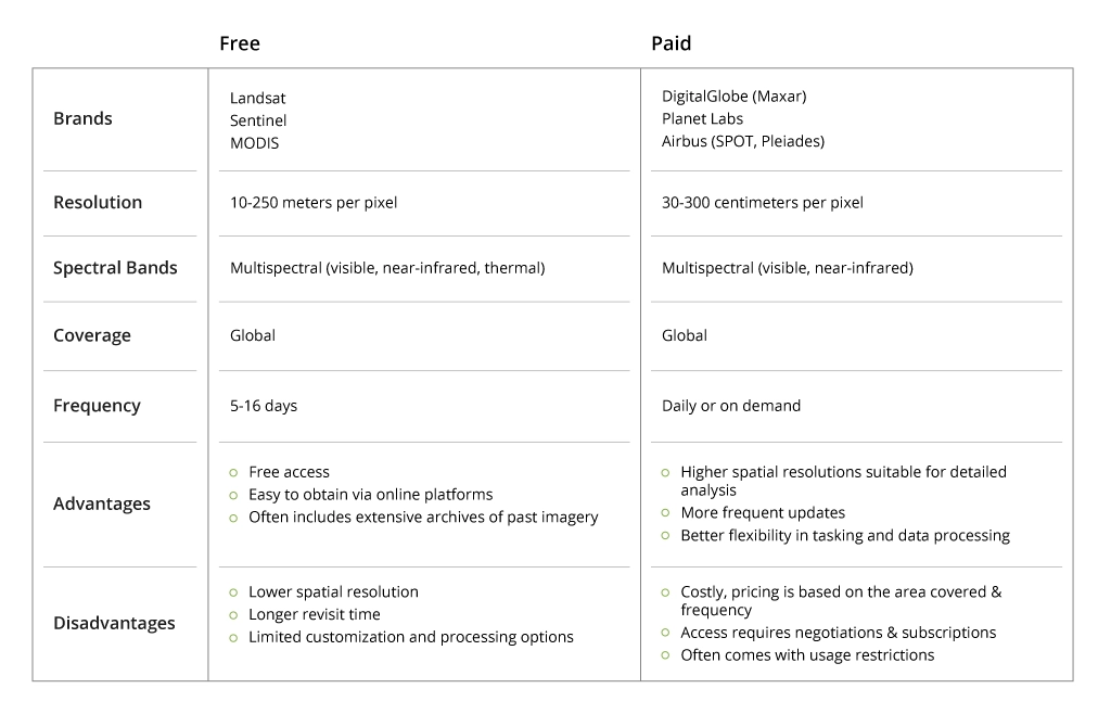
When choosing the satellite service, you should always consider the related use cases and available budget.
Agricultural Insurance and Agribusiness Scoring Models
There are two specific types of insurance in agriculture: harvest insurance and insurance from outer factors (index insurance) like droughts, freezes, natural disasters, and others. There are three approaches to index insurance:
- Based on local sensors (for instance, weather stations)
- Based on a claim from verification bodies (the authorities come to a place and document the incident)
- Based on satellite data.
Satellite imagery offers accurate, up-to-date information on crop health, yield potential, and environmental conditions to make informed decisions and effectively manage risks when granting agribusinesses insurance.
Data from satellites is also used for agribusiness scoring models to obtain a historical and up-to-date view of yield volumes, areas under specific cultures, and other parameters of interest. For instance, if a farmer wants to obtain operational funding, some advanced models consider the future yield a security asset. Scoring models are available for different crop types and define how much financing a farmer can get.
Benefits of Using Satellite-based Remote Sensing in Agriculture
Using remote sensing technology with satellite data provides numerous opportunities to cater to modern agricultural business needs.
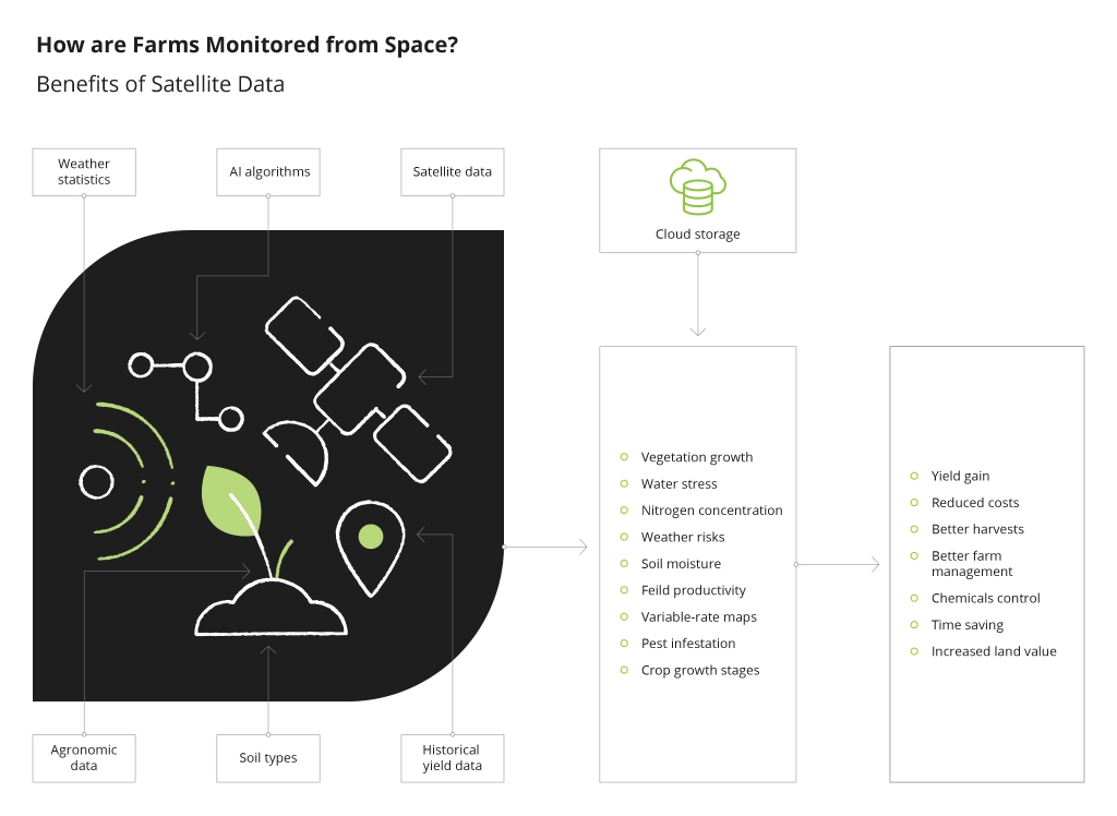
The primary benefits include:
- Improved decision-making: Analysis of near real-time and historical data on various agricultural parameters can minimize risks and enhance productivity.
- Enhanced resource efficiency through optimized use of water, fertilizers, and pesticides.
- Enabling autonomy and continuous monitoring: Satellite data integration with autonomous farming technologies and monitoring systems can enhance the precision and efficiency of agri-operations.
- Higher environmental sustainability through enabling precision agriculture and decreased resource consumption.
- Better cost-efficiency through lower input costs, operational automation, and reduced need for manual field inspections.
Conclusion
Integrating satellite-based remote sensing technology in agriculture brings numerous advantages and opportunities for farmers and other agribusiness market players. Yet, this powerful data source requires proper processing mechanisms and software solutions adjusted to specific business needs.
Infopulse offers advanced data services for agriculture to enhance operational efficiency and decision-making with satellite data. We implement scalable data storage platforms and AI/ML-based data processing systems to let the available data generate value for the agribusiness.

![Pros and Cons of CEA [thumbnail]](/uploads/media/thumbnail-280x222-industrial-scale-of-controlled-agriEnvironment.webp)
![Agriculture Robotics Trends [Thumbnail]](/uploads/media/thumbnail-280x222-what-agricultural-robotics-trends-you-should-be-adopting-and-why.webp)
![Hyperautomation Complex tasks in Agriculture [Thumbnail]](/uploads/media/thumbnail-280x222-hyperautomation-complex-tasks.webp)
![IoT as the Core of Digital Farming and Agriculture [thumbnail]](/uploads/media/280x222-iot-as-the-core-of-digital-farming-and-agriculture.webp)
![RPA Bots in Agriculture [thumbnail]](/uploads/media/thumbnail-280x222-the-potential-of-RPA-bots-in-agri.webp)
![Precision Farming Technologies [thumbnail]](/uploads/media/thumbnail-280x222-precision-farming.webp)
![Technology for Agriculture [thumbnail]](/uploads/media/thumbnail-280x222.webp)